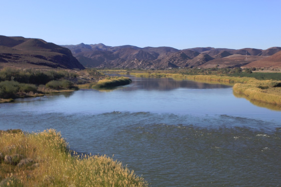
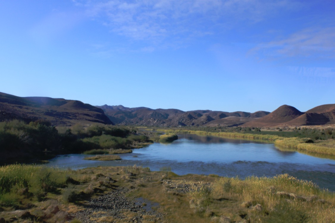
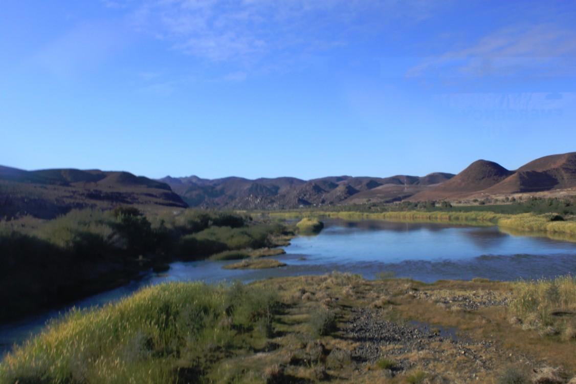
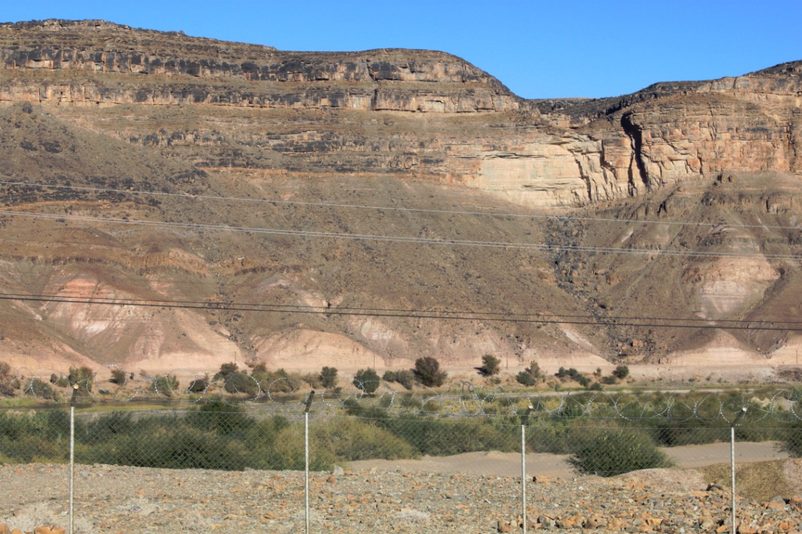
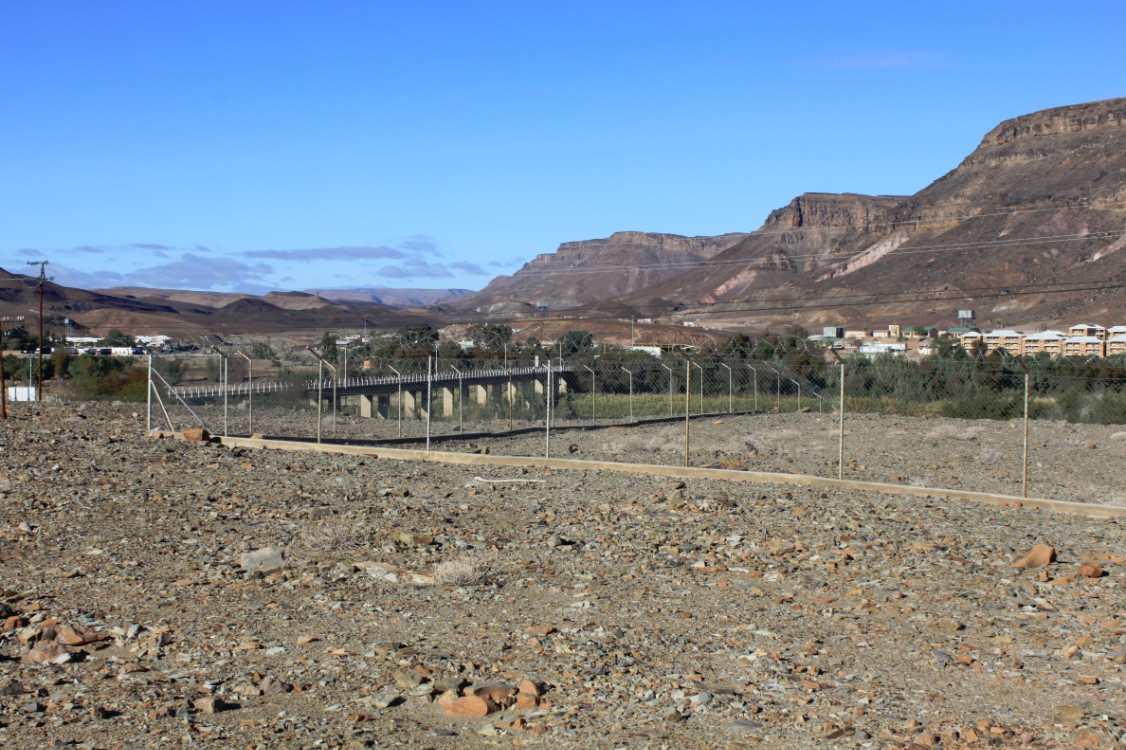
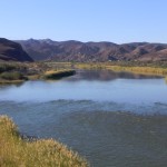
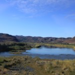
 After having spent a few days in Cape Town and after a long day of travel to Okiep and an early departure from Okiep for the final stretch to the border between South Africa and Namibia, it finally happened. After crossing the South African border and going through the necessary border formalities, The Wandelgek drove through No man’s land towards the Namibian border, and the road crossed the Orange River, which acts as a border river.
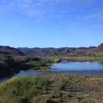
Then a large sign that read Welcome to Namibia was passed, which lent itself well for pictures and then the Namibian border was reached and was crossed after the neccesary formalities. The Wandelgek was now in Namibia.
A major difference between South Africa and Namibia was the temperature. You had dry desert air and even though it was the middle of winter here, it was (unlike in Cape Town where it was 17 to 18 degrees Celsius when The Wandelgek was there) well over 20 degrees Celsius. The more The Wandelgek traveled north, the more the temperature rose to over 30 degrees Celsius.
Namibia (/nəˈmɪbiə/, /næˈ–/), officially the Republic of Namibia (German: Republik Namibia; Afrikaans: Republiek van Namibië), and formerly German South-West Africa and then South West Africa, is a country in southern Africa whose western border is the Atlantic Ocean. It shares land borders with Zambia and Angola to the north, Botswana to the east and South Africa to the south and east. Although it does not border Zimbabwe, less than 200 metres of the Zambezi River (essentially a small bulge in Botswana to achieve a Botswana/Zambia micro-border) separates them at their closest points. It gained independence from South Africa on 21 March 1990, following the Namibian War of Independence. Its capital and largest city is Windhoek. Namibia is a member state of the United Nations (UN), the Southern African Development Community (SADC), the African Union (AU), and the Commonwealth of Nations.
The dry lands of Namibia were inhabited since early times by San, Damara, and Namaqua, and since about the 14th century AD by immigrating Bantu who came with the Bantu expansion. Most of the territory became a German Imperial protectorate in 1884 and remained a German colony until the end of World War I. In 1920, the League of Nations mandated the country to South Africa, which imposed its laws and, from 1948, its apartheid policy. The port of Walvis Bay and the offshore Penguin Islands had been annexed by the Cape Colony under the British crown by 1878 and had become an integral part of the new Union of South Africa at its creation in 1910.
Uprisings and demands by African leaders led the UN to assume direct responsibility over the territory. It recognised the South West Africa People’s Organisation (SWAPO) as the official representative of the Namibian people in 1973. Namibia, however, remained under South African administration during this time as South-West Africa. Following internal violence, South Africa installed an interim administration in Namibia in 1985. Namibia obtained full independence from South Africa in 1990, with the exception of Walvis Bay and the Penguin Islands, which remained under South African control until 1994.
Namibia has a population of 2.1 million people and a stable multi-party parliamentary democracy. Agriculture, herding, tourism and the mining industry – including mining for gem diamonds, uranium, gold, silver, and base metals – form the basis of Namibia’s economy. Given the presence of the arid Namib Desert, it is one of the least densely populated countries in the world. Namibia enjoys high political, economic and social stability.
History
The name of the country is derived from the Namib Desert, considered to be the oldest desert in the world. Before its independence in 1990, the area was known first as German South-West Africa (Deutsch-Südwestafrika), then as South-West Africa, reflecting the colonial occupation by the Germans and the South Africans (technically on behalf of the British crown reflecting South Africa’s dominion status within the British Empire).
Pre-colonial period
The dry lands of Namibia were inhabited since early times by San, Damara, Nama and, since about the 14th century AD, by immigrating Bantu who came with the Bantu expansion from central Africa. From the late 18th century onwards, Orlam clans from the Cape Colony crossed the Orange River and moved into the area that today is southern Namibia. Their encounters with the nomadic Nama tribes were largely peaceful. The missionaries accompanying the Orlams were well received by them, the right to use waterholes and grazing was granted against an annual payment. On their way further northwards, however, the Orlams encountered clans of the Herero tribe at Windhoek, Gobabis, and Okahandja which were less accommodating. The Nama-Herero War broke out in 1880, with hostilities ebbing only when Imperial Germany deployed troops to the contested places and cemented the status quo between Nama, Orlams, and Herero.
The first Europeans to disembark and explore the region were the Portuguese navigators Diogo Cão in 1485 and Bartolomeu Dias in 1486; still the region was not claimed by the Portuguese crown. However, like most of Sub-Saharan Africa, Namibia was not extensively explored by Europeans until the 19th century, when traders and settlers arrived, principally from Germany and Sweden. In the late 19th century Dorsland trekkers crossed the area on their way from the Transvaal to Angola. Some of them settled in Namibia instead of continuing their journey.
German rule
Namibia became a German colony in 1884 under Otto von Bismarck to forestall British encroachment and was known as German South-West Africa (Deutsch-Südwestafrika). However, the Palgrave mission by the British governor in Cape Town had determined that only the natural deep-water harbour of Walvis Bay was worth occupying – and this was annexed to the Cape province of British South Africa.
From 1904 to 1907, the Herero and the Namaqua took up arms against the Germans and in calculated punitive action by the German occupiers, the ‘first genocide of the Twentieth Century’ was committed. In the Herero and Namaqua genocide, 10,000 Nama (half the population) and approximately 65,000 Hereros (about 80% of the population) were systematically murdered. The survivors, when finally released from detention, were subjected to a policy of dispossession, deportation, forced labour, racial segregation and discrimination in a system that in many ways anticipated apartheid.
Most Africans were confined to so-called native territories, which later under South African rule post-1949 were turned into “homelands” (Bantustans). Indeed, some historians have speculated that the German genocide in Namibia was a model used by Nazis in the Holocaust. The memory of genocide remains relevant to ethnic identity in independent Namibia and to relations with Germany. The German government formally apologized for the Namibian genocide in 2004.
South African rule
South Africa occupied the colony in 1915 after defeating the German force during World War I and administered it from 1919 onward as a League of Nations mandate territory. Although the South African government desired to incorporate ‘South-West Africa’ into its territory, it never officially did so, although it was administered as the de facto ‘fifth province’, with the white minority having representation in the whites-only Parliament of South Africa, as well as electing their own local administration the SWA Legislative Assembly. The South African government also appointed the SWA administrator, who had extensive powers.
As a former German colony, Namibia originally drove on the right. After South Africa occupied South West Africa (now Namibia) during World War I, it was made a South African mandate by the League of Nations, and as such, drivers were ordered to drive on the left soon afterwards.
Following the League’s replacement by the United Nations in 1946, South Africa refused to surrender its earlier mandate to be replaced by a United Nations Trusteeship agreement, requiring closer international monitoring of the territory’s administration (along with a definite independence schedule). The Herero Chief’s Council submitted a number of petitions to the UN calling for it to grant Namibia independence during the 1950s. During the 1960s, when European powers granted independence to their colonies and trust territories in Africa, pressure mounted on South Africa to do so in Namibia. In 1966 the International Court of Justice dismissed a complaint brought by Ethiopia and Liberia against South Africa’s continued presence in the territory, but the U.N. General Assembly subsequently revoked South Africa’s mandate, while in 1971 the International Court of Justice issued an “advisory opinion” declaring South Africa’s continued administration to be illegal.
In response to the 1966 ruling by the International Court of Justice, South-West Africa People’s Organisation (SWAPO) military wing, People’s Liberation Army of Namibia, a guerrilla group began their armed struggle for independence, but it was not until 1988 that South Africa agreed to end its occupation of Namibia, in accordance with a UN peace plan for the entire region. During the South African occupation of Namibia, white commercial farmers, most of whom came as settlers from South Africa and represented 0.2% of the national population, owned 74% of the arable land. Outside the central-southern area of Namibia (known as the “Police Zone” since the German era and which contained the main towns, industries, mines and best arable land), the country was divided into “homelands”, the version of South African bantustan applied to Namibia, although only a few were actually established because indigenous Namibians often did not cooperate.
In 1978 the UN Security Council passed UN Resolution 435 which planned a transition toward independence for Namibia. Attempts to persuade South Africa to agree to the plan’s implementation were not successful until 1988 when the transition to independence finally started under a diplomatic agreement between South Africa, Angola and Cuba, with the USSR and the USA as observers, under which South Africa agreed to withdraw and demobilise its forces in Namibia. As a result, Cuba agreed to pull back its troops in southern Angola sent to support the MPLA in its war for control of Angola with UNITA.
A combined UN civilian and peace-keeping force called UNTAG (United Nations Transition Assistance Group) under Finnish diplomat Martti Ahtisaari was deployed from April 1989 to March 1990 to monitor the peace process, elections and supervise military withdrawals. As UNTAG began to deploy peacekeepers, military observers, police, and political workers, hostilities were briefly renewed on the day the transition process was supposed to begin. After a new round of negotiations, a second date was set and the elections process began in earnest. After the return of SWAPO exiles (over 46,000 exiles), Namibia’s first one-person one-vote elections for the constitutional assembly took place in November 1989. The official election slogan was “Free and Fair Elections”. This was won by SWAPO although it did not gain the two-thirds majority it had hoped for; the South African-backed Democratic Turnhalle Alliance (DTA) became the official opposition. The elections were peaceful and declared free and fair.
The Namibian Constitution adopted in February 1990 incorporated protection for human rights, compensation for state expropriations of private property, an independent judiciary and an executive presidency (the constituent assembly became the national assembly). The country officially became independent on 21 March 1990. Sam Nujoma was sworn in as the first President of Namibia watched by Nelson Mandela (who had been released from prison the previous month) and representatives from 147 countries, including 20 heads of state. Walvis Bay was ceded to Namibia in 1994 upon the end of Apartheid in South Africa.
After independence
Since independence Namibia has successfully completed the transition from white minority apartheid rule to parliamentary democracy. Multiparty democracy was introduced and has been maintained, with local, regional and national elections held regularly. Several registered political parties are active and represented in the National Assembly, although the Swapo Party has won every election since independence. The transition from the 15-year rule of President Sam Nujoma to his successor Hifikepunye Pohamba in 2005 went smoothly.
The Namibian government has promoted a policy of national reconciliation and issued an amnesty for those who had fought on either side during the liberation war. The civil war in Angola had some impact on Namibians living in the north of the country. In 1998, Namibia Defence Force (NDF) troops were sent to the Democratic Republic of the Congo as part of a Southern African Development Community (SADC) contingent. In August 1999, a secessionist attempt in the northeastern Zambezi Region was successfully quashed.
Geography
At 825,615 km2 (318,772 sq mi), Namibia is the world’s thirty-fourth largest country (after Venezuela). It lies mostly between latitudes 17° and 29°S (a small area is north of 17°), and longitudes 11° and 26°E.
Being situated between the Namib and the Kalahari deserts, Namibia is the country with the least rainfall in sub-Saharan Africa.
The Namibian landscape consists generally of five geographical areas, each with characteristic abiotic conditions and vegetation with some variation within and overlap between them: the Central Plateau, the Namib Desert, the Great Escarpment, the Bushveld, and the Kalahari Desert.
The Central Plateau runs from north to south, bordered by the Skeleton Coast to the northwest, the Namib Desert and its coastal plains to the southwest, the Orange River to the south, and the Kalahari Desert to the east. The Central Plateau is home to the highest point in Namibia at Königstein elevation 2,606 metres (8,550 ft).
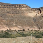
The Namib Desert is a broad expanse of hyper-arid gravel plains and dunes that stretches along Namibia’s entire coastline. It varies between 100 to many hundreds of kilometres in width. Areas within the Namib include the Skeleton Coast and the Kaokoveld in the north and the extensive Namib Sand Sea along the central coast.
The Great Escarpment swiftly rises to over 2,000 metres (6,562 ft). Average temperatures and temperature ranges increase further inland from the cold Atlantic waters, while the lingering coastal fogs slowly diminish. Although the area is rocky with poorly developed soils, it is significantly more productive than the Namib Desert. As summer winds are forced over the Escarpment, moisture is extracted as precipitation.
The Bushveld is found in north eastern Namibia along the Angolan border and in the Caprivi Strip. The area receives a significantly greater amount of precipitation than the rest of the country, averaging around 400 mm (15.7 in) per year. The area is generally flat and the soils sandy, limiting their ability to retain water.
The Kalahari Desert, an arid region shared with South Africa and Botswana, is one of Namibia’s well-known geographical features. The Kalahari, while popularly known as a desert, has a variety of localised environments, including some verdant and technically non-desert areas. One of these, known as the Succulent Karoo, is home to over 5,000 species of plants, nearly half of them endemic; Approximately 10 percent of the world’s succulents are found in the Karoo. The reason behind this high productivity and endemism may be the relatively stable nature of precipitation.
Namibia’s Coastal Desert is one of the oldest deserts in the world. Its sand dunes, created by the strong onshore winds, are the highest in the world. Because of the location of the shoreline – at the point where the Atlantic’s cold water reaches Africa – there is often extremely dense fog. Near the coast there are areas where the dunes are vegetated with hammocks. Namibia has rich coastal and marine resources that remain largely unexplored.
Climate
Namibia extends from 17°S to 25°S: climatically the range of the sub-Tropical High Pressure Belt, arid is the overall climate description descending from the Sub-Humid (mean rain above 500 mm) through Semi-Arid between 300 and 500 mm (embracing most of the waterless Kalahari) and Arid from 150 to 300 mm (these three regions are inland from the western escarpment) to the Hyper-Arid coastal plain with less than a 100 mm mean. Temperature maxima are limited by the overall elevation of the entire region: only in the far south, Warmbad for instance, are mid-40 °C maxima recorded.
Typically the sub-Tropical High Pressure Belt, with frequent clear skies, provides more than 300 days of sunshine per year. It is situated at the southern edge of the tropics; the Tropic of Capricorn cuts the country about in half. The winter (June – August) is generally dry, both rainy seasons occur in summer, the small rainy season between September and November, the big one between February and April. Humidity is low, and average rainfall varies from almost zero in the coastal desert to more than 600 mm in the Caprivi Strip. Rainfall is however highly variable, and droughts are common. The last bad rainy season with rainfall far below the annual average occurred in summer 2006/07.
Weather and climate in the coastal area are dominated by the cold, north-flowing Benguela current of the Atlantic Ocean which accounts for very low precipitation (50 mm per year or less), frequent dense fog, and overall lower temperatures than in the rest of the country. In Winter, occasionally a condition known as Bergwind (German: Mountain breeze) or Oosweer (Afrikaans: East weather) occurs, a hot dry wind blowing from the inland to the coast. As the area behind the coast is a desert, these winds can develop into sand storms with sand deposits in the Atlantic Ocean visible on satellite images.
The Central Plateau and Kalahari areas have wide diurnal temperature ranges of up to 30 °C.
Efundja, the annual flooding of the northern parts of the country, often causes not only damage to infrastructure but loss of life. The rains that cause these floods originate in Angola, flow into Namibia’s Cuvelai basin, and fill the Oshanas (Oshiwambo: flood plains) there. The worst floods so far occurred in March 2011 and displaced 21,000 people.
Water sources
Namibia is the driest country in sub-Saharan Africa and depends largely on groundwater. With an average rainfall of about 350 mm per annum, the highest rainfall occurs in the Caprivi in the northeast (about 600 mm per annum) and decreases in a westerly and southwesterly direction to as little as 50 mm and less per annum at the coast. The only perennial rivers are found on the national borders with South Africa, Angola, Zambia, and the short border with Botswana in the Caprivi. In the interior of the country surface water is available only in the summer months when rivers are in flood after exceptional rainfalls. Otherwise, surface water is restricted to a few large storage dams retaining and damming up these seasonal floods and their runoff. Thus, where people don’t live near perennial rivers or make use of the storage dams, they are dependent on groundwater to provide for their water needs. From a geographic and water consumer viewpoint, it is therefore clear that a very large proportion of the Namibian population is dependent on groundwater for their (economic) livelihood. Despite considerable investment in drilling, borehole design and construction as well as pumping and maintenance, groundwater is usually the most economic way of supplying water. The advantage of using groundwater sources is that even isolated communities and those economic activities located far from good surface water sources such as mining, agriculture, and tourism can be supplied from groundwater over nearly 80% of the country.
More than 100,000 boreholes have been drilled in Namibia over the past century. One third of these boreholes have been drilled dry; therefore, better and more sustainable groundwater exploration methods are needed.
Communal Wildlife Conservancies
Namibia is one of few countries in the world to specifically address conservation and protection of natural resources in its constitution. Article 95 states, “The State shall actively promote and maintain the welfare of the people by adopting international policies aimed at the following: maintenance of ecosystems, essential ecological processes, and biological diversity of Namibia, and utilisation of living natural resources on a sustainable basis for the benefit of all Namibians, both present and future.”
In 1993, the newly formed government of Namibia received funding from the United States Agency for International Development (USAID) through its Living in a Finite Environment (LIFE) Project. The Ministry of Environment and Tourism with the financial support from organisations such as USAID, Endangered Wildlife Trust, WWF, and Canadian Ambassador’s Fund, together form a Community Based Natural Resource Management (CBNRM) support structure. The main goal of this project is promote sustainable natural resource management by giving local communities rights to wildlife management and tourism.
Mining and electricity
Providing 25% of Namibia’s revenue, mining is the single most important contributor to the economy. Namibia is the fourth largest exporter of non-fuel minerals in Africa and the world’s fourth largest producer of uranium. There has been significant investment in uranium mining and Namibia is set to become the largest exporter of uranium by 2015. Rich alluvial diamond deposits make Namibia a primary source for gem-quality diamonds. While Namibia is known predominantly for its gem diamond and uranium deposits, a number of other minerals are extracted industrially such as lead, tungsten, gold, tin, fluorspar, manganese, marble, copper and zinc. There are offshore gas deposits in the Atlantic Ocean that are planned to be extracted in the future. According to “The Diamond Investigation”, a book about the global diamond market, from 1978, De Beers, the largest diamond company, bought most of the Namibian diamonds, and would continue to do so, because “whatever government eventually comes to power they will need this revenue to survive”.
Domestic supply voltage is 220V AC. Electricity is generated mainly by thermal and hydroelectric power plants. Non-conventional methods of electricity generation also play some role. Encouraged by the rich uranium deposits the Namibian government plans to erect its first nuclear power station by 2018, also uranium enrichment is envisaged to happen locally.
Tourism
Tourism is a major contributor (14.5%) to Namibia’s GDP, creating tens of thousands of jobs (18.2% of all employment) directly or indirectly and servicing over a million tourists per annum. The country is among the prime destinations in Africa and is known for ecotourism which features Namibia’s extensive wildlife.
There are many lodges and reserves to accommodate eco-tourists. Sport Hunting is also a large, and growing component of the Namibian economy, accounting for 14% of total tourism in the year 2000, or $19.6 million US dollars, with Namibia boasting numerous species sought after by international sport hunters. In addition, extreme sports such as sandboarding, skydiving and 4x4ing have become popular, and many cities have companies that provide tours. The most visited places include the Caprivi Strip, Fish River Canyon, Sossusvlei, the Skeleton Coast Park, Sesriem, Etosha Pan and the coastal towns of Swakopmund, Walvis Bay and Lüderitz.
Demographics
Namibia has the second-lowest population density of any sovereign country, after Mongolia. The majority of the Namibian population is of Bantu-speaking origin – mostly of the Ovambo ethnicity, which forms about half of the population – residing mainly in the north of the country, although many are now resident in towns throughout Namibia. Other ethnic groups are the Herero and Himba people, who speak a similar language, and the Damara, who speak the same “click” language as the Nama.
In addition to the Bantu majority, there are large groups of Khoisan (such as Nama and San), who are descendants of the original inhabitants of Southern Africa. The country also contains some descendants of refugees from Angola. There are also two smaller groups of people with mixed racial origins, called “Coloureds” and “Basters”, who together make up 8.0% (with the Coloureds outnumbering the Basters two to one). There is a large Chinese minority in Namibia.
Whites (mainly of Afrikaner, German, British and Portuguese origin) make up about 7.0% of the population. Although their percentage of population is decreasing due to emigration they still form the second-largest population of European ancestry, both in terms of percentage and actual numbers, in Sub-Saharan Africa after that of South Africa. Most Namibian whites and nearly all those of mixed race speak Afrikaans and share similar origins, culture, and religion as the white and coloured populations of South Africa. A smaller proportion of whites (around 30,000) trace their family origins directly back to German colonial settlers and maintain German cultural and educational institutions. Nearly all Portuguese settlers came to the country from the former Portuguese colony of Angola. The 1960 census reported 526,004 persons in what was then South-West Africa, including 73,464 whites (14%).
Namibia conducts a census every ten years. After independence the first Population and Housing Census was carried out in 1991, further rounds followed in 2001 and 2011. The data collection method is to count every person resident in Namibia on the census reference night, wherever they happen to be. This is called the de facto method. For enumeration purposes the country is demarcated into 4,042 enumeration areas. These areas do not overlap with constituency boundaries to get reliable data for election purposes as well.
The 2011 Population and Housing Census counted 2,113,077 inhabitants of Namibia. Between 2001 and 2011 the annual population growth was 1.4%, down from 2.6% in the previous ten–year period.
Religion
The Christian community makes up 80%–90% of the population of Namibia, with at least 50% of these Lutheran. 10%–20% of the population hold indigenous beliefs.
Missionary activities during the 1800s resulted in many Namibians to convert to Christianity. While most Namibian Christians are Lutheran, there also are Roman Catholic, Methodist, Anglican, African Methodist Episcopal, Dutch Reformed, Rhenish Christians, and Mormons (the Church of Jesus Christ of Latter-Day Saints).
Namibia is home to a small Jewish community of about 100 members.
Language
Since 1991 English is the only official language, though only about 3% of the population speaks it as a home language. Its implementation is focused on the civil service, education and the broadcasting system.
Up to 1990, German and Afrikaans were also official languages. Long before Namibia’s independence from South Africa, SWAPO was of the opinion that the country should become officially monolingual, choosing this approach in contrast to that of its neighbour South Africa (which granted all 11 of its major languages official status), which was seen by them as “a deliberate policy of ethnolinguistic fragmentation.” Consequently, SWAPO instituted English as the sole official language of Namibia. Some other languages have received semi-official recognition by being allowed as medium of instruction in primary schools. It is expected of private schools to follow the same policy as state schools, and “English language” is a compulsory subject.
Half of all Namibians speak Oshiwambo as their first language, whereas the most widely understood and spoken language is Afrikaans. Among the younger generation, English is rapidly gaining hold. Both Afrikaans and English are used primarily as a second language reserved for public communication, but small first-language groups exist throughout the country. Portuguese has been added as a second language of instruction in the schools.
According to the 2011 census, the most common languages are Oshiwambo (the most spoken language for 49% of households), Nama/Damara (11.3%), Afrikaans (10.4%), Kavango (9%), Otjiherero (9%).
While the official language is English, most of the white population speaks either German or Afrikaans. Even today, 99 years after the end of the German colonial era, the German language plays a leading role as a commercial language. Afrikaans is spoken by 60% of the white community, German is spoken by 32%, English is spoken by 7% and Portuguese by 1%. Geographical proximity to Portuguese-speaking Angola explains the relatively high number of Portuguese speakers; in 2011 these were estimated to be 100,000, or 4–5% of the total population.
Largest cities
| 1 | Windhoek | Khomas | 322,500 | |
| 2 | Walvis Bay | Erongo | 85,000 | |
| 3 | Rundu | Kavango | 63,431 | |
| 4 | Swakopmund | Erongo | 44,725 | |
| 5 | Oshakati | Oshana | 36,540 | |
| 6 | Rehoboth | Hardap | 28,843 | |
| 7 | Katima Mulilo | Zambezi | 28,362 | |
| 8 | Otjiwarongo | Otjozondjupa | 28,249 | |
| 9 | Ondangwa | Oshana | 22,822 | |
| 10 | Okahandja | Otjozondjupa | 22,639 |