 South Africa was the first of five southern african countries which The Wandelgek visited this summer. The adventurous journey started at Capetown and proceeded along the west coast through Namaqualand to the border with Namibia.
Flight
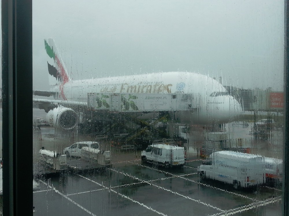
The flight with Emirates from Amsterdam Schiphol to Dubai and then via transfer to Cape Town was quite exciting. In the Netherlands on July 18, 2015, a great storm had unleashed.

In the Netherlands, a big storm erupted …
I had left early to the airport, traveling by train but it was already raining heavily and the storm had gale force.
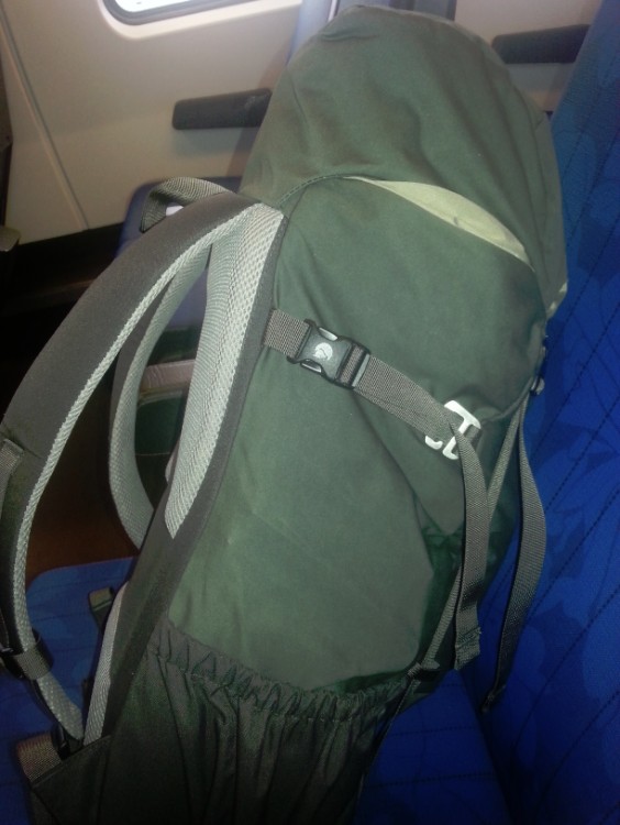
My brand new Fjallraven daypack
On the train I read on nu.nl (a dutch news website) that there were already more than 30 flights canceled.
I had not heard from the travel agency or the airline about a cancellation so I hoped for the continuation of the flight, but when I looked outside and saw the trees cracking in the heavy storm I realized that maybe it would be better if the flight would be canceled now … gulp …
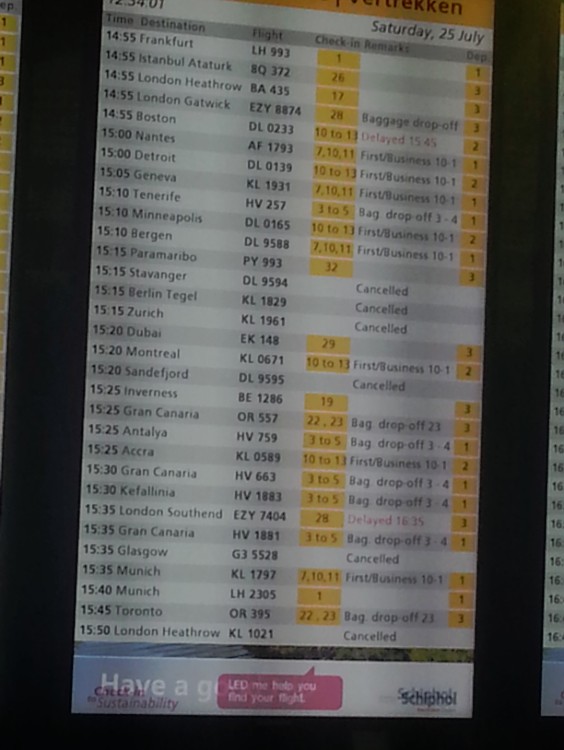
Many flights, particularly with the smaller aircraft, were canceled …
Arriving at the airport I immediately checked whether the flight would depart and when I looked at the departures at around 15:20 I saw one after the other had been canceled, … but phew … not the flight to Dubai.
So I checked in and went through passport control quickly and then did some last minute shopping in the tax free area. I still needed a South African electricity plug and a multi-plug with USB ports and also I needed a larger photo memory card for my camera.
The Emirates airplane …
When I had bought everything it was time for a nice large beer.
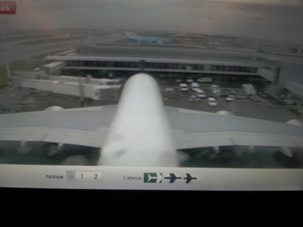
Via two onboard cameras I could follow the whole flight …
Boarding the plane was still on track, but then it went wrong. The storm went haywire and only the very large aircraft were allowed to leave when the wind slowed down a bit. That was the case and the plane taxied to the start position, but just before departure the wind was unleashed in full force again and the departure was delayed. The plane had to start taxiing again and then had to wait behind four other waiting planes. An hour later than planned we finally lifted off. That was not at all a smooth lift off. It quickly became obvious how heavy this storm was. But above the clouds it suddenly got quieter. The flight from Dubai to Africa had begun and I was able to follow everything through two onboard cameras …
South Africa, officially the Republic of South Africa, is a country in Africa. It is bounded on the south by 2,798 kilometers of coastline of southern Africa stretching along the South Atlantic and Indian oceans, on the north by the neighbouring countries of Namibia, Botswana and Zimbabwe, and on the east by Mozambique and Swaziland, and surrounding the kingdom of Lesotho. South Africa is the 25th-largest country in the world by land area, and with close to 53 million people, is the world’s 24th-most populous nation.
South Africa is a multiethnic society encompassing a wide variety of cultures, languages, and religions. Its pluralistic makeup is reflected in the constitution’s recognition of 11 official languages, which is among the highest number of any country in the world. Two of these languages are of European origin: Afrikaans developed from Dutch and serves as the first language of most white and coloured South Africans; English reflects the legacy of British colonialism, and is commonly used in public and commercial life, though it is fourth-ranked as a spoken first language.
The country is one of the few in Africa never to have had a coup d’état, and regular elections have been held for almost a century. But the vast majority of black South Africans were not enfranchised until 1994. During the 20th century, the black majority sought to recover its rights from the dominant white minority, with this struggle playing a large role in the country’s recent history and politics. The National Party imposed apartheid in 1948, institutionalizing previous racial segregation. After a long and sometimes violent struggle by the African National Congress and other anti-apartheid activists both inside and outside the country, discriminatory laws began to be repealed or abolished from 1990 onwards.
About 80 percent of South Africans are of sub-Saharan African ancestry, divided among a variety of ethnic groups speaking different Bantu languages, nine of which have official status. The remaining population consists of Africa’s largest communities of European (white), Asian (Indian), and multiracial (coloured) ancestry. Since 1994, all ethnic and linguistic groups have had political representation in the country’s constitutional democracy, which comprises a parliamentary republic and nine provinces. South Africa is often referred to as the “Rainbow Nation” to describe the country’s newly developing multicultural diversity in the wake of segregationist apartheid ideology.
South Africa is ranked as an upper-middle income economy by the World Bank, and is considered to be a newly industrialised country. Its economy is the second-largest in Africa, and the 34th-largest in the world. In terms of purchasing power parity, South Africa has the seventh-highest per capita income in Africa. However, poverty and inequality remain widespread, with about a quarter of the population unemployed and living on less than US$1.25 a day. Nevertheless, South Africa has been identified as a middle power in international affairs, and maintains significant regional influence.
History
Prehistoric finds
South Africa contains some of the oldest archaeological and human fossil sites in the world. Extensive fossil remains have been recovered from a series of caves in Gauteng Province. The area is a UNESCO World Heritage site and has been termed the Cradle of Humankind. The sites include Sterkfontein, which is one of the richest hominin fossil sites in the world. Other sites include Swartkrans, Gondolin Cave Kromdraai, Coopers Cave and Malapa. The first hominin fossil discovered in Africa, the Taung Child was found near Taung in 1924. Further hominin remains have been recovered from the sites of Makapansgat in Limpopo, Cornelia and Florisbad in the Free State, Border Cave in KwaZulu-Natal, Klasies River Mouth in eastern Cape and Pinnacle Point, Elandsfontein and Die Kelders Cave in Western Cape. These sites suggest that various hominid species existed in South Africa from about three million years ago starting with Australopithecus africanus. These were succeeded by various species, including Australopithecus sediba, Homo ergaster, Homo erectus, Homo rhodesiensis, Homo helmei and modern humans, Homo sapiens. Modern humans have inhabited Southern Africa for at least 170,000 years.
Within the Vaal River valley, pebble tools have been located.
Bantu colonisation
Settlements of Bantu-speaking peoples, who were iron-using agriculturists and herdsmen, were already present south of the Limpopo River (now the northern border with Botswana and Zimbabwe) by the 4th or 5th century CE. (See Bantu expansion.) They displaced, conquered and absorbed the original Khoisan speakers, the Khoikhoi and San peoples. The Bantu slowly moved south. The earliest ironworks in modern-day KwaZulu-Natal Province are believed to date from around 1050. The southernmost group was the Xhosa people, whose language incorporates certain linguistic traits from the earlier Khoisan people. The Xhosa reached the Great Fish River, in today’s Eastern Cape Province. As they migrated, these larger Iron Age populations displaced or assimilated earlier peoples. In Mpumalanga, several stone circles have been found along with the stone arrangement that has been named Adam’s Calendar.
Portuguese contacts
At the time of European contact, the dominant ethnic group were Bantu-speaking peoples who had migrated from other parts of Africa about one thousand years before. The two major historic groups were the Xhosa and Zulu peoples.
In 1487, the Portuguese explorer Bartolomeu Dias led the first European voyage to land in southern Africa. On 4 December, he landed at Walfisch Bay (now known as Walvis Bay in present-day Namibia). This was south of the furthest point reached in 1485 by his predecessor, the Portuguese navigator Diogo Cão (Cape Cross, north of the bay). Dias continued down the western coast of southern Africa. After 8 January 1488, prevented by storms from proceeding along the coast, he sailed out of sight of land and passed the southernmost point of Africa without seeing it. He reached as far up the eastern coast of Africa as, what he called, Rio do Infante, probably the present-day Groot River, in May 1488, but on his return he saw the Cape, which he first named Cabo das Tormentas (Cape of Storms). His King, John II, renamed the point Cabo da Boa Esperança, or Cape of Good Hope, as it led to the riches of the East Indies. Dias’ feat of navigation was later immortalised in Luís de Camões’ Portuguese epic poem, The Lusiads (1572).
European colonisation
By the early 17th century, Portugal’s maritime power was starting to decline, and English and Dutch merchants competed to oust Lisbon from its lucrative monopoly on the spice trade. Representatives of the British East India Company did call sporadically at the Cape in search of provisions as early as 1601, but later came to favour Ascension Island and St. Helena as alternative ports of refuge. Dutch interest was aroused after 1647, when two employees of the Dutch East India Company were shipwrecked there for several months. The sailors were able to survive by obtaining fresh water and meat from the natives. They also sowed vegetables in the fertile soil. Upon their return to Holland they reported favourably on the Cape’s potential as a “warehouse and garden” for provisions to stock passing ships for long voyages.
In 1652, a century and a half after the discovery of the Cape sea route, Jan van Riebeeck established a refreshment station at the Cape of Good Hope, at what would become Cape Town, on behalf of the Dutch East India Company. The Dutch transported slaves from Indonesia, Madagascar, and India as labour for the colonists in Cape Town. As they expanded east, the Dutch settlers met the southwesterly migrating Xhosa people in the region of the Fish River. A series of wars, called the Cape Frontier Wars, were fought over conflicting land and livestock interests.
Great Britain took over the Cape of Good Hope area in 1795, to prevent it from falling under control of the French First Republic, which had invaded the Dutch Republic. Given its standing interests in Australia and India, Great Britain wanted to use Cape Town as an interim port for its merchants’ long voyages. The British returned Cape Town to the Dutch Batavian Republic in 1803, the Dutch East India Company having effectively gone bankrupt by 1795.
The British annexed the Cape Colony in 1806, and continued the frontier wars against the Xhosa; the British pushed the eastern frontier through a line of forts established along the Fish River and they consolidated the territory by encouraging British settlement. During the 1820s both the Boers (original Dutch, Flemish, German, and French settlers) and the British 1820 Settlers claimed land in the north and east of the country. Conflicts arose among the Xhosa, Zulu, Sotho and Boer groups who competed to expand their territories.
In the first two decades of the 19th century, the Zulu people grew in power and expanded their territory under their leader, Shaka. Shaka’s warfare led indirectly to the Mfecane (“crushing”) that devastated and depopulated the inland plateau in the early 1820s. An offshoot of the Zulu, the Matabele people created a larger empire that included large parts of the highveld under their king Mzilikazi.
During the early 1800s, many Dutch settlers departed from the Cape Colony, where they had been subjected to British control. They migrated to the future Natal, Orange Free State, and Transvaal regions. The Boers founded the Boer Republics: the South African Republic (now Gauteng, Limpopo, Mpumalanga and North West provinces) and the Orange Free State (Free State).
The discovery of diamonds in 1867 and gold in 1884 in the interior started the Mineral Revolution and increased economic growth and immigration. This intensified the European-South African efforts to gain control over the indigenous peoples. The struggle to control these important economic resources was a factor in relations between Europeans and the indigenous population and also between the Boers and the British.
The Anglo-Zulu War was fought in 1879 between the British Empire and the Zulu Kingdom. Following Lord Carnarvon’s successful introduction of federation in Canada, it was thought that similar political effort, coupled with military campaigns, might succeed with the African kingdoms, tribal areas and Boer republics in South Africa. In 1874, Sir Henry Bartle Frere was sent to South Africa as High Commissioner for the British Empire to bring such plans into being. Among the obstacles were the presence of the independent states of the South African Republic and the Kingdom of Zululand and its army. The Zulu nation spectacularly defeated the British at the Battle of Isandlwana. Eventually though the war was lost resulting in the end of the Zulu nation’s independence.
The Boer Republics successfully resisted British encroachments during the First Boer War (1880–1881) using guerrilla warfare tactics, which were well suited to local conditions. The British returned with greater numbers, more experience, and new strategy in the Second Boer War (1899–1902) but suffered heavy casualties through attrition; nonetheless, they were ultimately successful.
Within the country, anti-British policies among white South Africans focused on independence. During the Dutch and British colonial years, racial segregation was mostly informal, though some legislation was enacted to control the settlement and movement of native people, including the Native Location Act of 1879 and the system of pass laws. Power was held by the ethnic European colonists.
Eight years after the end of the Second Boer War and after four years of negotiation, an act of the British Parliament (South Africa Act 1909) granted nominal independence, while creating the Union of South Africa on 31 May 1910. The Union was a dominion that included the former territories of the Cape and Natal colonies, as well as the republics of Orange Free State and Transvaal.
The Natives’ Land Act of 1913 severely restricted the ownership of land by blacks; at that stage natives controlled only 7% of the country. The amount of land reserved for indigenous peoples was later marginally increased.
In 1931 the union was fully sovereign from the United Kingdom with the passage of the Statute of Westminster, which abolishes the last powers of the British Government on the country. In 1934, the South African Party and National Party merged to form the United Party, seeking reconciliation between Afrikaners and English-speaking “Whites”. In 1939 the party split over the entry of the Union into World War II as an ally of the United Kingdom, a move which the National Party followers strongly opposed.
In 1948, the National Party was elected to power. It strengthened the racial segregation begun under Dutch and British colonial rule. The Nationalist Government classified all peoples into three races and developed rights and limitations for each. The white minority (less than 20%) controlled the vastly larger black majority. The legally institutionalised segregation became known as apartheid. While whites enjoyed the highest standard of living in all of Africa, comparable to First World Western nations, the black majority remained disadvantaged by almost every standard, including income, education, housing, and life expectancy. The Freedom Charter, adopted in 1955 by the Congress Alliance, demanded a non-racial society and an end to discrimination.
Republic
On 31 May 1961, the country became a republic following a referendum in which white voters narrowly voted in favour thereof (the British-dominated Natal province rallied against the issue). Queen Elizabeth II was stripped of the title Queen of South Africa, and the last Governor-General, namely Charles Robberts Swart, became State President. As a concession to the Westminster system, the presidency remained parliamentary appointed and virtually powerless until P. W. Botha’s Constitution Act of 1983, which (intact in these regards) eliminated the office of Prime Minister and instated a near-unique “strong presidency” responsible to parliament. Pressured by other Commonwealth of Nations countries, South Africa left the organisation in 1961 and was readmitted only in 1994.
Despite opposition both within and outside the country, the government legislated for a continuation of apartheid. The security forces harshly oppressed resistance movements, and violence became widespread, with anti-apartheid activists using strikes, marches, protests, and sabotage by bombing and other means. The African National Congress (ANC) was a major resistance movement. Apartheid became increasingly controversial, and some Western nations and institutions began to boycott business with South Africa because of its racial policies and suppression of civil rights. International sanctions, divestment of holdings by investors accompanied growing unrest and oppression within South Africa.
In the late 1970s, South Africa initiated a programme of nuclear weapons development. In the following decade, it produced six deliverable nuclear weapons.
The Mahlabatini Declaration of Faith, signed by Mangosuthu Buthelezi and Harry Schwarz in 1974, enshrined the principles of peaceful transition of power and equality for all, the first of such agreements by black and white political leaders in South Africa. Ultimately, F. W. de Klerk opened bilateral discussions with Nelson Mandela in 1993 for a transition of policies and government.
In 1990 the National Party government took the first step towards dismantling discrimination when it lifted the ban on the African National Congress and other political organisations. It released Nelson Mandela from prison after twenty-seven years’ serving a sentence for sabotage. A negotiation process followed. With approval from an predominantly white referendum, the government repealed apartheid legislation. South Africa also destroyed its nuclear arsenal and acceded to the Nuclear Non-Proliferation Treaty. South Africa held its first universal elections in 1994, which the ANC won by an overwhelming majority. It has been in power ever since. The country rejoined the Commonwealth of Nations.
In post-apartheid South Africa, unemployment has been extremely high as the country has struggled with many changes. While many blacks have risen to middle or upper classes, the overall unemployment rate of blacks worsened between 1994 and 2003. Poverty among whites, previously rare, increased. In addition, the current government has struggled to achieve the monetary and fiscal discipline to ensure both redistribution of wealth and economic growth. Since the ANC-led government took power, the United Nations Human Development Index of South Africa has fallen, while it was steadily rising until the mid-1990s. Some may be attributed to the HIV/AIDS pandemic, and the failure of the government to take steps to address it in the early years.
In May 2008, riots left over sixty people dead. The Centre on Housing Rights and Evictions estimates over 100,000 people were driven from their homes. The targets were mainly migrants and refugees seeking asylum, but a third of the victims were South African citizens. In a 2006 survey, the South African Migration Project concluded that South Africans are more opposed to immigration than anywhere else in the world. The United Nations High Commissioner for Refugees in 2008 reported over 200,000 refugees applied for asylum in South Africa, almost four times as many as the year before. These people were mainly from Zimbabwe, though many also come from Burundi, Democratic Republic of the Congo, Rwanda, Eritrea, Ethiopia and Somalia. Competition over jobs, business opportunities, public services and housing has led to tension between refugees and host communities. While xenophobia is still a problem, recent violence has not been as widespread as initially feared.
Geography
South Africa is located at the southernmost region of Africa, with a long coastline that stretches more than 2,500 km (1,553 mi) and along two oceans (the South Atlantic and the Indian). At 1,219,912 km2 (471,011 sq mi), South Africa is the 25th-largest country in the world and is comparable in size to Colombia. Mafadi in the Drakensberg at 3,450 m (11,320 ft) is the highest peak in South Africa. Excluding the Prince Edward Islands, the country lies between latitudes 22° and 35°S, and longitudes 16° and 33°E.
The interior of South Africa consists of a vast, in most places, almost flat, plateau with an altitude of between 1,000 m (3,300 ft) and 2,100 m (6,900 ft), highest in the east, sloping gently downwards towards the west and north, and slightly less so to the south and south-west. This plateau is surrounded by the Great Escarpment whose eastern, and highest stretch is known as the Drakensberg.
The south and south-western parts of the plateau (at approximately 1100–1800 m above sea level), and the adjoining plain below (at approximately 700–800 m above sea level – see map on the right) is known as the Great Karoo, which consists of sparsely populated scrubland. To the north the Great Karoo fades into the even drier and more arid Bushmanland, which eventually becomes the Kalahari desert in the very north-west of the country. The mid-eastern, and highest part of the plateau is known as the Highveld. This relatively well-watered area is home to a great proportion of the country’s commercial farmlands, and contains its largest conurbation (Gauteng Province). To the north of Highveld, from about the 25° 30′ S line of latitude, the plateau slopes downwards into the Bushveld, which ultimately gives way to the Limpopo lowlands or Lowveld.
The coastal belt, below the Great Escarpment, moving clockwise from the northeast, consists of the Limpopo Lowveld, which merges into the Mpumalanga Lowveld, below the Mpumalanga Drakensberg (the eastern portion of the Great Escarpment). This is hotter, drier and less intensely cultivated than the Highveld above the escarpment. The Kruger National Park, located in the provinces of Limpopo and Mpumalanga in northeastern South Africa, occupies a large portion of the Lowveld covering 19,633 square kilometres (7,580 sq mi.) South of the Lowveld the annual rainfall increases as one enters KwaZulu-Natal Province, which, especially near the coast, is subtropically hot and humid. The KwaZulu-Natal – Lesotho international border is formed by the highest portion of the Great Escarpment, or Drakensberg, which reaches an altitude of over 3,000 m (9,800 ft). The climate at the foot of this part of the Drakensberg is temperate.
The coastal belt below the south and south-western stretches of the Great Escarpment contains several ranges of Cape Fold Mountains which run parallel to the coast, separating the Great Escarpment from the ocean. (These parallel ranges of fold mountains are shown on the map, above left. Note the course of the Great Escarpment to the north of these mountain ranges.) The land (at approximately 400–500 m above sea level) between two of these ranges of fold mountains in the south (i.e. between the Outeniqua and Langeberg ranges to the south and the Swartberg range to the north) is known as the Little Karoo, which consists of semi-desert scrubland similar to that of the Great Karoo, except that its northern strip along the foothills of the Swartberg Mountains, has a somewhat higher rainfall and is therefore more cultivated than the Great Karoo. The Little Karoo is historically, and still, famous for its ostrich farming around the town of Oudtshoorn. The lowland area (700–800 m above sea level) to the north of the Swartberg mountain range up to the Great Escarpment is the lowland part of the Great Karoo (see map at top right), which is climatically and botanically almost indistinguishable from the Karoo above the Great Escarpment. The narrow coastal strip between the most seaward Cape Fold Mountain range (i.e. the Langeberg-Outeniqua mountains) and the ocean has a moderately high year-round rainfall, especially in the George-Knysna-Plettenberg Bay region, which is known as the Garden Route. It is famous for the most extensive areas of indigenous forests in South Africa (a generally forest-poor country).
In the south-west corner of the country the Cape Peninsula forms the southernmost tip of the coastal strip which borders the Atlantic Ocean, and ultimately terminates at the country’s border with Namibia at the Orange River. The Cape Peninsula has a Mediterranean climate, making it and its immediate surrounds the only portion of Africa south of the Sahara which receives most of its rainfall in winter.
The greater Cape Town metropolitan area is situated on the Cape Peninsula and is home to 3.7 million people according to the 2011 population census. It is the country’s legislative capital.
The coastal belt to the north of the Cape Peninsula is bounded on the west by the Atlantic Ocean and the first row of north-south running Cape Fold Mountains to the east. The Cape Fold Mountains peter out at about the 32° S line of latitude, after which the coastal plain is bounded by the Great Escarpment itself. The most southerly portion of this coastal belt is known as the Swartland and Malmesbury Plain, which is an important wheat growing region, relying on winter rains. The region further north is known as Namaqualand, which becomes more and more arid as one approaches the Orange River. The little rain that falls, tends to fall in winter, which results in one of the world’s most spectacular displays of flowers carpeting huge stretches of veld in spring (August – September).
South Africa also has one possession, the small sub-Antarctic archipelago of the Prince Edward Islands, consisting of Marion Island (290 km2 or 110 sq mi) and Prince Edward Island (45 km2 or 17 sq mi) (not to be confused with the Canadian province of the same name).
Provinces
Each of the nine provinces is governed by a unicameral legislature, which is elected every five years by party-list proportional representation. The legislature elects a Premier as head of government, and the Premier appoints an Executive Council as a provincial cabinet. The powers of provincial governments are limited to topics listed in the Constitution; these topics include such fields as health, education, public housing and transport.
The provinces are in turn divided into 52 districts: 8 metropolitan and 44 district municipalities. The district municipalities are further subdivided into 226 local municipalities. The metropolitan municipalities, which govern the largest urban agglomerations, perform the functions of both district and local municipalities.
| Province | Provincial capital | Largest city | Area (km2) | Population (2013) |
|---|---|---|---|---|
| Eastern Cape | Bhisho | Port Elizabeth | 168,966 | 6,620,100 |
| Free State | Bloemfontein | Bloemfontein | 129,825 | 2,753,200 |
| Gauteng | Johannesburg | Johannesburg | 18,178 | 12,728,400 |
| KwaZulu-Natal | Pietermaritzburg | Durban | 94,361 | 10,456,900 |
| Limpopo | Polokwane | Polokwane | 125,754 | 5,518,000 |
| Mpumalanga | Nelspruit | Nelspruit | 76,495 | 4,128,000 |
| North West | Mahikeng | Rustenburg | 104,882 | 3,597,600 |
| Northern Cape | Kimberley | Kimberley | 372,889 | 1,162,900 |
| Western Cape | Cape Town | Cape Town | 129,462 | 6,016,900 |
Non-indigenous cookery
During the pioneering days of the 17th century, new foods such as biltong, droëwors (dried sausage) and rusks evolved locally out of necessity.
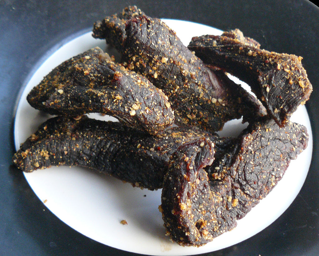
Biltong…