C. Inner Mongolia 2019
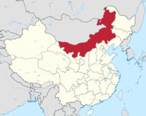 Inner Mongolia, officially the Inner Mongolia Autonomous Region, is an autonomous region of China. Its border includes two-thirds of the length of China’s border with the country of Mongolia. Inner Mongolia also accounts for a small section of China’s border with Russia (Zabaykalsky Krai). Its capital is Hohhot; other major cities include Baotou, Chifeng, Tongliao, and Ordos.
The autonomous region was established in 1947, incorporating the areas of the former Republic of China provinces of Suiyuan, Chahar, Rehe, Liaobei, and Xing’an, along with the northern parts of Gansu and Ningxia.
Its area makes it the third largest Chinese administrative subdivision, constituting approximately 1,200,000 km2 (463,000 sq mi) and 12% of China’s total land area. Due to its long span from east to west, Inner Mongolia is geographically divided into eastern and western divisions. The eastern division is often included in Northeastern China (Dongbei), with major cities including Tongliao, Chifeng, Hailar, and Ulanhot. The western division is included in North China, with major cities including Baotou and Hohhot. It recorded a population of 24,706,321 in the 2010 census, accounting for 1.84% of Mainland China’s total population. Inner Mongolia is the country’s 23rd most populous province-level division. Han Chinese make up the majority of the population in the region; Mongols constitute a significant minority with over 4 million people, making it the largest Mongol population in the world (larger than that of the country Mongolia). Inner Mongolia is one of the more economically developed provinces in China with annual GDP per capita at US$14,343 (2022), ranked 8th in the nation. The official languages are Mandarin and Mongolian, the latter of which is written in the traditional Mongolian script, as opposed to the Mongolian Cyrillic alphabet, which is used in the country of Mongolia, formerly described as Outer Mongolia.